Introduction: An Overview of Tropical Rainforests
By Amy Hedlund, Janel Ota, and Mai Setoyama
By Amy Hedlund, Janel Ota, and Mai Setoyama
Tropical rainforest is an ecosystem that is characterized by its warm temperatures year round and its tall canopy of trees. Tropical rainforests have an average of 50-260 inches of precipitation a year. These rainforests have high precipitation due to the ITCZ (intertropical convergence zone), which basically acts as a rain machine, thus causing this large precipitation in the tropical rainforests. In addition, orographic precipitation plays a large role in the climate of the rainforests. Orographic precipitation is when air is forced to rise because of a mountain. When it rises, it condenses and precipitates on that side of the mountain. The other side of the mountain is called the rain shadow side, as it has low precipitation (10). While rainforests cover less than 6% of the world’s land, they produce 40% of the world’s oxygen. This is because the tropical rainforests are extremely rich in species of plants, animals, and insects (8). Rainforests have four distinct layers to them: the emergent layer, upper canopy, low canopy, and the floor.
Emergent Layer:
This the is the layer containing the trees tall enough to grow up above the main canopy. The trees in this layer are 100 to 240 feet tall, and they grow above the forest with canopies and are widely spaced. These trees have straight, tall, smooth trunks with a shallow root system, but large buttresses that can range up to 30 feet so they can support their own growth (8).
Canopy Layer:
 |
| The Layers of the Tropical Rainforest (Image 4) |
This is the upper layer of the main canopy. These trees are 60 to 130 feet tall, and the block the majority of the light to the plants below. A lot of the rainforests animals live in the upper canopy because there is so much food in this layer. The leaves in these trees are shaped to allow rain to run off of them to keep them as dry as possible (8).
Understory:
This layer consists of trees that are about 60 feet tall. It is characterized by small trees, shrubs, and other plants. This level is constantly in shade because of the upper canopy that blocks out all of the sunlight (8).
Forest Floor:
On the forest floor there are few shrubs and plants because of the lack of sunlight. Less than 1% of the sunlight that shines on a tropical rainforest shines all the way down to the forest floor. Thus keeping the forest floor fairly clear of plants. The top soil on the floor is thin and is poor quality as well (8).
Spatial Scale of the Tropical Rainforests in Ecuador:
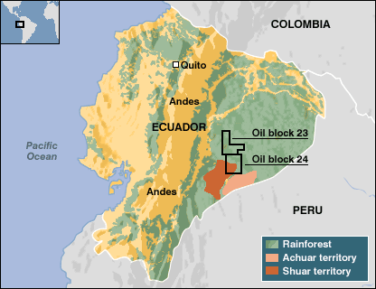 |
| The tropical rainforest composition of Ecuador (Image 5) |
Ecuador is a fairly small country, covering 283,560km2 or 0.2% of the world's land surface (4). There are 3 regions of Ecuador, and going from left to right, they are La Costa, La Sierra, and El Oriente (6). The tropical rainforests of Ecuador is located in the El Oriente region which makes up 1.6% of the Amazon basin (9). The tropical rainforests of Ecuador cover about 40% of the land in the country (3). The image above displays the regions in Ecuador that are comprised of Tropical Rainforest:
What did the ecosystem historically look like?
The tropical rainforests in Ecuador have been known for its great diversity. They have a large number of species, including almost half of the planet's species of birds, which total 8,500, as well as more than 1200 butterflies and thousands of reptiles and mammals (2). Compared to the world, the area has the third highest number of amphibian species and sixth highest number of mammal species (4). The area contains the highest amount of plant species in the world, containing about 10% of currently known species (4). In the 1940s there was the first oil exploration in the tropical rainforests in ecuador, and this was the start of dramatic negative impacts on the preservation of the rainforest (11).
 |
| Tropical Rainforest of Ecuador (Image 6) |
Human Impacts on the Tropical Rainforests of Ecuador
Humans have had a very negative impact on the tropical rainforest for Ecuador. The negative impacts on the tropical rainforests include gold and rubber, oil, and logging.
Gold and Rubber
Negative human impacts of the tropical rainforest in Ecuador began as early as the 15th century when invaders were on a quest for gold. In their quests they destroyed many resources and trees and plants of the rainforest. In addition, the boom of rubber collection in the 19th and 20th centuries also had great negative impacts on the forest. It brought in many more invaders and continued the destruction of resources (11).
Oil, Deforestation, and Mining:
Furthermore, the discovery of oil in this part of Ecuador in the 1960s has caused even greater destruction. With the discovery of the oil, the forests have been destroyed in order to create pipelines and roads. One example of a road cut down to make oil rigging easier is the Auca road, which was built in 1980 to create access to oil fields. Colonists cut town the trees and sold the timber to create farms for themselves (11). The tropical rainforests of Ecuador have the highest deforestation rate and worst environmental record in South America (1). The deforestation is occurring at one of the world’s highest rates, with about 300,000 hectares of land destroyed per year (4). The deforestation rate has been continuing to increase since the late 1990s, and between 1990 and 2005, Ecuador lost 21% of it forest cover (1). In addition, oil exploitation has caused major damage to the rainforests in Ecuador, and there are many long-standing law suits against industries drilling for oil and destroying the forests (3). The issue of deforestation is propelled further with mining, as it requires new roads to be built for access, and thus requires the destruction of the forests (11).
 |
| Table of the deforestation of the rainforests in Ecuador (Image 9) |
 |
| Destruction and deforestation caused by oil pipelines (Image 2) |
 |
| Image displaying deforestation caused by the building of roads (Image 7) |
What benefits do people get from the ecosystem?
The tropical rainforests are extremely biodiverse. They are beneficial because they are home to almost half of the world’s species of plants, animals, and insects (5). Their great biodiversity causes them to be a beautiful and a great tourist attraction for those looking to explore the outdoors and witness a lot of nature. Also, the rainforests are important in the creation of oxygen for the planet. Due to the large amount of plants in the tropical rainforests, photosynthesis in the forests recycle carbon dioxide and produce a large amount of oxygen for the planet (5). The rainforests are rich in alkaloids, which biochemists believe are important protecting plants from disease and insect attacks, and alkaloids from higher plants also can be used in medicine (5). In addition, 80% of the developed world’s diet originated in tropical rainforests (5). Below are a list of common fruits, vegetables, and spices the originated in the tropical rainforest (5):
- Fruits: avocados, coconuts, figs, oranges, lemons, grapefruit, bananas, guavas, pineapple, mangos and tomatoes.
- Vegetables: corn, potatoes, squash, yams
- Spices: black pepper, cayenne, chocolate, cinnamon, cloves, ginger, sugar cane, tumeric, coffee, vanilla
- Other: nuts, cashews and rice
Protected Areas and Their Status:
As of 2004, the government is officially protecting 15.6% of Ecuador’s tropical rainforest (7)
Yasuní National Park
 |
| Yasuni National Park (Image 8) |
This is Ecuador’s largest national park. The biodiversity in this national park is immense. It is the home of over 550 species of birds, and of all the bird species found in the Amazon basin, 44% of them live in this national park. It also has a large diversity in tree species. This park is barely inhabited, but there are some Huaorani families and groups who have lived in the region of this park for many generations (11).
Even though this park is protected by the government, energy companies have still been performing oil drilling activities for over 45 years. This oil extraction is causing the area to suffer from an increasing amount of deforestation alerts. Along with this issue, human activities such as illegal logging and animal poaching has also been increasingly occurring the park. All of these issues have been posing a significant threat to this park’s large biodiversity (12).
The Cuyabeno Wildlife Reserve
This wildlife reserve is Ecuador’s second largest protected area, covering over 600,000 square kilometers of land. This reserve protects the rainforest, lakes, and rivers that surround the area around the Rio Cuyabeno. The area contains a vast variety of animals, including insects, capibaras, and pink river dolphins. It is also home to over 15 species of monkeys, 300 species of trees, and 500 species of birds (13).
The Sumaco-Galeras National Park is a nature reserve which is located between the two provinces of Orellana and Napo. Covering 205,249 square kilometers, it is located in the middle of the Ecuadorian Amazon, containing a vast variety of flora and fauna. Giant armadillos, bears, and parakeets are some of the animals that are found in this national forest (14).
Since the park’s location is close to natural oil reserves, the area has been threatened by deforestation issues. To solve this problem, the Sumaco and Napo-Galeras area was classified as a Biosphere Reserve in 1993. This sparked the development of numerous conservation projects, allowing the park to protect plants and animals while sustaining ecotourism (14).
What Does the Future of this Ecosystem look like?
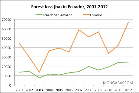 |
Graph displaying the deforestation in the
rainforests of Ecuador (Image 3)
|
How to Maintain Balance Between People and the Land:
 |
| Indigenous tribes in the tropical rainforests of Ecuador (Image 1) |
The destruction of the rainforests is being caused by the creation of roads and pipelines for oil access, so in order to maintain the land, the oil riggings needs to be stopped. Right now there is no safe way for people to access the oil without destroying the land. Therefore, renewable energy sources need to be utilized in order to decrease the high demand for oil. If people use more renewable energy, the demand for oil as energy will decrease, and thus the need to exploit the oil in this biodiverse region will go away. There currently are people that live in this region of Ecuador and they are able to live harmoniously in rainforest without destroying it but still being able to get all of their necessary nutrients (11). There are currently nine different tribes of indigenous people living in the Ecuadorian Amazon. They are the Secoya and Siona, Cofanes/A’i, Waorani, Tagaei/Taromenani, Kichwa, Zapara, Achuar, Shuar, Shiwiar (11). The map to the left displays these indigenous tribes in the tropical rainforests of Ecuador.
References
1. "Ecuador: Environmental
Profile." Ecuador: Environmental Profile. Web. 26 Nov.
2. "Ecuador
Rainforest." Ecuador Rainforest. Web. 26 Nov. 2015.
3. "Northern South
America: Northwestern Ecuador and Southwestern Colombia."
WorldWildlife.org. World
Wildlife Fund, Web. 26 Nov. 2015
4. "Causes and Consequences of
Deforestation in Ecuador." Causes and Consequences
of Deforestation
in Ecuador. Web. 26 Nov. 2015
5. "Rainforest
Preservation Benefits." Rainforest Preservation Benefits. Web.
26 Nov.
6. "Ecuador Rainforest Home to
One of the Worst Cases of Oil Pollution Ever.
"Ecuador
Rainforest And Its Devastation by Oil Production. Web. 26 Nov. 2015
<http://www.tropical-rainforest-animals.com/Ecuador-Rainforest.html>.
7. "Ecuador: Environmental
Profile." Ecuador: Environmental Profile. Web. 26 Nov.
8. "Rainforest
Biomes." Rainforest Biomes. Web. 26 Nov. 2015
<http://www.blueplanetbiomes.org/rainforest.htm>.
9. "Amazon Rainforest
Tours." Amazon Rainforest Tours. Web. 26 Nov. 2015
<http://www.tenanaui.com/english/amazon-rainforest-tours/>.
10. "Orographic
Precipitation | Meteorology." Encyclopedia Britannica Online.
Encyclopedia
Britannica, Web. 26 Nov. 2015.
<http://www.britannica.com/science/orographic-precipitation>.
11. "About the Ecuadorian
Amazon Rainforest." About the Ecuadorian Amazon
Rainforest.
Web. 26 Nov. 2015 <http://www.eosecuador.travel/about/about-
amazon.html>.
12. "Deforestation Ramping up
in Yasuni as Ecuador Sets to Open up National Park
to Drilling." Mongabay
Environmental News., 29 July 2014. Web. 26 Nov. 2015. <http://news.mongabay.com/2014/07/deforestation-ramping-up-in-yasuni-as-ecuador-sets-to-open-up-national-park-to-drilling/>.
13. "Explore Cuyabeno
Wildlife Reserve – 5 Days." TerraDiversa. Web. 26 Nov.
2015. <http://www.terradiversa.com/tour/explore-cuyabeno-wildlife-reserve-5-days>.
14. "Sumaco-Napo-Galeras
National Park - In the Heart of the Ecuadorian Amazon."
Sumaco-Napo-Galeras
National Park, Ecuador. Web. 26 Nov. 2015.
<http://www.ecuador.com/protected-areas/sumaco-napo-galeras/>.
Images:
1. Sprague, Drake. Map of
Ecuador’s Amazon and Lowland Tribes. Digital
image. Drake
& Megan Sprague. 6 Aug. 2014. Web. 26 Nov. 2015.
<http://drakeandmegan.com/2014/08/06/ac-14-reveals-an-ever-evolving-movement/>.
2. Farnsworth, Bruce. Petroleum
"Development" in Ecuador. Digital image. Amazon
Rainforest.
Web. 26 Nov. 2015 <http://www.brucefarnsworth.com/index.php#mi=2&pt=1&pi=10000&s=13&p=3&a=0&at=0>.
3. Butler, Rhett. Amazon
Destruction. Digital image. Mongabay.com. 9 Jan. 2006. Web.
26 Nov. 2015 <http://rainforests.mongabay.com/amazon/amazon_destruction.html>.
4. Rainforest Stratas.
Digital image. Amazon Rainforest. Weebly, Web. 26 Nov. 2015.
<http://amazonrainforestfirstperiod.weebly.com/layers.html>.
5. Voss, Michael. The
tropical rainforest composition of Ecuador. Digital image. BBC
News. 3
Mar. 2005. Web. 26 Nov. 2015.
<http://news.bbc.co.uk/2/hi/americas/4308537.stm>.
6. Krohne, David. Rainforest
near Tiputini Research Station. Digital
image. Wabash.edu.
Web. 26 Nov. 2015.
<https://www.wabash.edu/photo_album/home.cfm?photo_id=6873&photo_album_id=1576>.
7. Gachet, Karla. Oil
Access Road. Digital image. Amazon Watch. 12 Nov. 2013. Web.
26 Nov. 2015.
<http://amazonwatch.org/news/2013/1112-stunning-aerial-
photos-reveal-ecuador-building-roads-deeper-into-richest-rainforest-on-earth>.
8. Yasuni National Park.
Digital image. Pachamama Alliance. BBC News, 15 Apr.
2014. Web. 26 Nov.
2015.
<http://www.pachamama.org/news/ecuador-will-vote-on-oil-drilling-in-yasuni-national-park>.
9.
"Ecuador Forest Information and Data." Ecuador Forest
Information and Data.
Web. 27 Nov. 2015. <http://rainforests.mongabay.com/deforestation
/2000/Ecuador.htm>.
No comments:
Post a Comment